Kayaking Environment
East Coast Kayaking's Guidelines for our kayaking activities are based on:
Victorian Department of Education Guidelines
Australian Activity Standards
Maritime Safety Victoria requirements
Australian Canoeing safety recommendations
Key considerations of the environment in which the activity takes place:
Definitions
Water Environment
Location of Activity
Communication
Weather
Transportation
Definitions
The Victorian Department of Education categorises Victorian waters based on definitions by Maritime Safety Victoria as:
Coastal offshore - all waters greater than two nautical miles from the coast. Heading offshore is a serious undertaking and operators must ensure they are properly prepared. Additional safety equipment ensures that operators have a means of raising the alarm in the event of an emergency. This equipment will provide an increased level of safety for all vessels heading offshore.
Coastal inshore - all waters along the Victorian coast within two nautical miles (aside from Inland waters and enclosed waters).
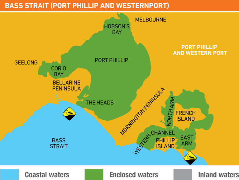
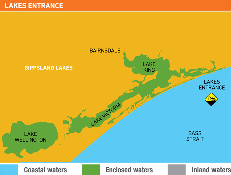
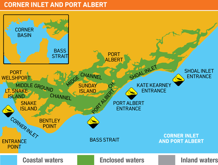
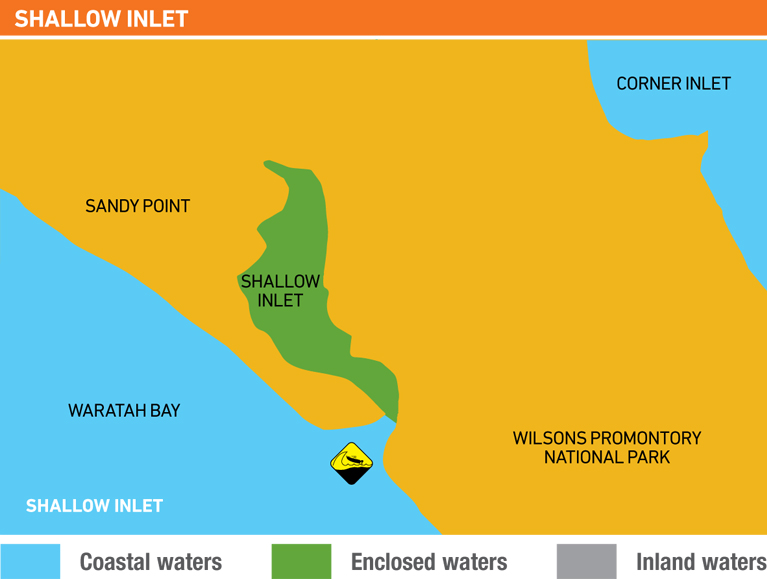
Enclosed waters - bays, inlets, estuaries and waterways that open to the sea (specific waterways and port waters listed on the Maritime Safety website - see maps below for examples. Click an image to go to Maritime Safety website).
Inland waters - rivers, lakes and waterways that do not open to the sea (aside from port waters).
The Victorian Department of Education groups Inland Waters and Enclosed waters as Inland waters and Coastal Offshore and inshore waters as Open waters, for the purposes of supervision ratios. Our programs typically take place on inland waters and enclosed water.
Water Environment
Water environments encountered kayaking are subject to a wide range of environmental conditions, which are considered when planning and conducting kayaking activities.
Kayaking activities may be affected by conditions such as:
- size and turbidity of the body of water
- the strength of tides and currents
- the presence and power of waves
- the temperature of the water
Location of Activity
A specific assessment of suitability of the location is made prior to each trip. Location selection is based on first hand knowledge of supervising staff. Where this is impractical, planning and supervising staff will be thoroughly familiar with the general characteristics and conditions found in similar locations, and have consulted with people who can supply recent and first-hand knowledge of the locations being considered.
When assessing the suitability of a location, consideration is made of:
- the potential to support educational objectives
- the level of access to the resources, services and facilities - including campsites, water, walking trails, toilets, shelter from extreme weather, or interpretive information
- the level of access to communications and external assistance, in the event of an emergency, or extreme weather conditions. The more effectively remote the location is, then the more self-contained and self–reliant the group must be
- the potential exposure to environmental hazards and difficulties
- the activity ability and fitness of students.
Examples of locations commonly used in our activities are shown here.
Contact with relevant authorities will be made in order to access up-to-date management information and to determine any access and permit requirements. This may include: Parks Victoria, Emergency Services, relevant government departments.
Communication
East Coast Kayaking's communication strategy enables instructors to receive weather forecasts and warnings, communicate with the school, and engage support in the case of an incident or emergency.
- Communication equipment is chosen based on current communication technology.
- A communication strategy is in operation for the group during the program and to enable communication with outside parties including the school and emergency services.
Instructors are aware of the limitations of the communication strategy (ie. level of mobile phone coverage, VHF radio and satellite phone coverage in a activity location).
Weather
The weather forecast for the activity location is monitored in the days leading up to the program and on the day the program commences. If the program extends overnight, the weather is monitored and assessed throughout the program and based on that information (daily weather forecasts and Warnings) staff are prepared to cancel, modify or relocate the activity at any time.
Weather information is accessed directly from the Bureau of Meteorology website: particularly marine forecasts and MetEye.
Weather warning telephone services are also accessible by mobile phone while on program (call costs apply from mobiles):
Coastal, Land Weather and Flood Warnings: 1300 659 217
Full State Telephone Weather Service: 1900 955 363
Coastal Waters Telephone Service: 1900 969 930
Transportation
The transportation of groups to and from activity locations must be carefully considered. Bus transport to and from activities is usually the responsibility of the school, but can be included as part of a multi-day package.
Vehicles used to transport students comply with VicRoads registration requirements:
- Drivers will comply with all licensing requirements.
- Equipment carried inside vehicles is securely stowed.
- Students are supervised by a minimum of one adult, in addition to the bus driver, during travel.
Drivers of vehicles with up to and including 12 seats (including the driver) will have a current drivers license.
Drivers of vehicles with 13 or more seats (including the driver) have a current license appropriate for the vehicle and will:
- undertake a daily vehicle safety check
- hold a current driver's certificate, see: Application for Accreditation to Drive a Private Bus at Taxi Services Commission - Bus Drivers
- complete the driver log book, see: National driving hours regulations
- comply with the National driving hours regulations
In circumstances where a staff member drives a vehicle transporting students, the program allows for adequate rest prior and breaks consistent with the national driving hours regulations.


