North of Cowie Beach, the vegetation changed from lush rainforest to scrubby dry Queensland bush, but it was still a delight to behold from the water. At Archer Point we landed, however a fisherman’s four-wheel drive vehicle caught fire and set the surrounding grasslands and bush on fire. After tracking the fire’s progress we relocated from our preferred campsite to a position where we would not be trapped by the fire. Moving on, we landed at a beautiful beach at Quarantine Bay then rounded the coast and paddled up the Endeavour River to Cooktown. Until this time, during the days the steady state wind was generally SE 10-knots in the morning and rising to SE 15–20-knots in the afternoon. We had some light rain and overcast days but generally by the afternoon it was quite sunny.
At Cooktown we took a day off to repair two of the kayaks, as they needed fibreglass patching. My kayak had been cracked open at the seam-line, where one of the team accidentally rammed his stern into my midships. Mark by this time had enough of paddling the Torres with its quirks, so went back to his SeaBear. He spent sometime trying to find out how water was leaking into his rear hatch and getting past the bulkhead into his day hatch. He also modified the rear deck to secure the kayak wheels to. Lyndon’s 22-year old Skua was the only serviceable one at this stage of the expedition..
After a morning repairing the kayaks, we sorted our provisions and water for the next major stage to Portland Roads. For this second stage, we took vitals for fourteen days. I carried 39-litres of potable water, mostly in MSR Dromedary bags. I used two 10-litre, one six-litre and one four-litre Dromedary bags as well two-litre and one-litre water canisters. I found the six-litre Dromedary bag, fitted nicely behind my rudder pedal bar in the cockpit and did not become dislodged. Mark used multiple two and one litre soft drink bottles for his water.
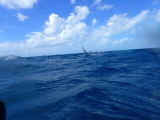
Before departing Cooktown a Yachty approached me and informed me that it was blowing 20–30 knots out past Cape Bedford, which was 30-kilometres away. After rounding Cape Bedford we got into the lee of the wind; and here I was informed of a route change. Instead of going around to Elim Beach we crossed over to Low Wooded Island in quite boisterous conditions. Unbeknown to me, Lyndon had lost his chart overboard rounding Cape Bedford with the charted route to Low Wooded Island. After Lyndon consulted the Navionics chart, we set out on a compass bearing into the two to three metre seas with no visual navigation references. Having no visual navigational references, we all knew that we would drift to the west of our destination, but we were looking for a navigation feature. Once we found our reference feature, Conical Rock that was 10-kilometres out from the cape, we were able to work out our drift and make a dead-reckoning correction to the destination 7-kilometres away, that was still not visible. By this stage the Mirage 582’s cockpit was a swimming pool due to the cockpit coaming coming away from the deck: so much for Mirage Kayaks motto printed on the deck: “Expedition Proven”!
At this point I should point out how I like to navigate. I prefer a chart and or map on my deck, of the route and a deck compass. I also carry a Silva baseplate compass in my PFD pocket. I do not rely on my GPS as I had a waterproof device that leaked on one of my Bass Strait crossing, rendering it useless. I still carry a GPS for my check-navigation and plot but turn it on as required. I also carry my waterproof GPS in a waterproof clear bag.
On reaching our destination we searched for a route through the coral to the beach to enable us to launch unimpeded the morning. Next morning we broke camp early and launched at first light without breakfast, so we could get past the coral reef. In overcast and strong winds conditions, we crossed over to Cape Flattery and did surf landings on the lee-shore. After breakfast and several attempts, we all got off the beach and headed for the Turtle Group of islands.
By time we had crossed over to the islands the cloud had gone and the wind had become light. We admired this beautiful part of FNQ as we sat on a tropical uninhabited island looking at turquoise blue waters, white sand and palm trees. The only draw back was that you could not go down to the waters edge. That afternoon we repaired the kayak’s hull damage, which they all obtained on the reef of Low Wooded Island.
We continued north and visited Coquet Island and camped on Leggatt Island. The next day while heading to Barrow Point, my bow pearled and picked up a yellow sea snake. After Barrow Island we followed the coast to Hales Beach. Along the way we saw brumbies and wild pigs as well as many Leatherback turtles.